UNESCO Global Geopark San’in Kaigan Geopark
Geological features, the natural environment, people’s lives from the formation of the Sea of Japan
HISTORY
The San’in Kaigan Geopark, Valuable Heritage of the Earth’s Activities
Offering opportunities to observe valuable and beautiful geological formations and conditions, such as various rocks and geological strata, various coastal forms, waterfalls and valleys, the San’in Kaigan Geopark can be called the “heritage of the earth’s activities.”
About Geopark
“Geo” is a prefix signifying “earth” and “land.” A geopark is a kind of natural park containing geological heritage that has great scientific importance and value or that is simply beautiful to look at. Geological and geomorphological conditions not only reflect the earth’s history but also have direct relevance to people’s lives and cultures. Geoparks help us learn about and enjoy the earth’s activities as a set of heritages.
In 2004, with UNESCO’s support, geoparks of European countries, China, Japan, and other countries came together to form the Global Geoparks Network (GGN). In October 2010, the San’in Kaigan Geopark obtained admission to the GGN. In September 2014, the San’in Kaigan Geopark expanded its area and was readmitted to the GGN. In 2015, the GGN became an official program of UNESCO.
How to Enjoy Geoparks
In a geopark, besides watching and experiencing its magnificent nature, you can observe various living things and people’s lifestyles, histories, and cultures that have relevance to the development of its earth heritage. At each geopark facility, you are provided with various kinds of information about the geopark. Facilities are also staffed by full-time geo-guides who give easy-to-understand explanations on the region. We recommend participating in one of the tours led by geo-guides. With their help, you will be able to see the landscapes from a new perspective, gain insight into what makes the geopark’s earth heritage special, and better understand its historical and cultural backgrounds. When the study tour is over, take time to enjoy other aspects of the geopark. For example, you can enjoy delicious local foods or refresh in the hot springs, which is one of the gifts from “geo”.
Themes and Characteristics of the San’in Kaigan Geopark
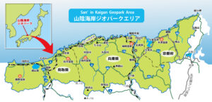
Stretching widely from Kyoto Prefecture (Kyotango City) to Hyogo Prefecture (Toyooka City, Kami Town, and Shin’onsen Town) to Tottori Prefecture (Iwami Town and Tottori City) and largely overlapping with San’in Kaigan National Park, the San’in Kaigan Geopark lies about 120 km east and west from the eastern edge of Kyotango City to the western edge of Tottori City, respectively. With an area 2458.44 ㎢, the Geopark is a little larger than the Tokyo Metropolitan Area.
The Geopark has had diverse geomorphological and geological features from the time when the Japan Sea was born to the present. One can observe living things, and people’s lifestyles, cultures, and histories that reflect such features.
One of the outstanding characteristics of the San’in Kaigan Geopark is that it contains many valuable geomorphological and geological assets. They include igneous rocks and geological strata that are related to the formation of the Sea of Japan about 25 million years ago, and diverse coastal terrains, such as ria shorelines and dunes formed by the sea-level change and crustal movement in the Sea of Japan.
In the San’in Kaigan Geopark, there are varied terrain and geological conditions that range from the days when Japan was still part of the Asian Continent to the present day. The Geopark also has a cultural and historical heritage that has developed in its diverse natural surroundings.
Geomorphological and Geological Features
(1)Distribution of various igneous rocks and sedimentary rock layers related to the formation of the Sea of Japan and their exposure on the rocky coast
(2)Varied landforms along the coast of the Sea of Japan
(3)Volcanic product and volcanic landform resulting from the igneous activity that continued after the formation of the Sea of Japan
(4)Location where it was discovered that reversed period of geomagnetic field occurred in the Quaternary era (Basalt rock at Genbudo Cave)
(5)Abundant hot spring resources resulting from the igneous activity
(6)Active faults and coastal terraces indicating Quaternary crustal movement that has appeared along the coast of the Sea of Japan
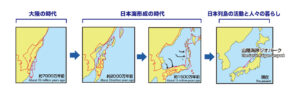
The History of the Earth of the San’in Kaigan Divided into Three Periods
The process in which the land where the San’in Kaigan Geopark is located was formed can be largely divided into three parts, namely “the period when Japan was part of the Asian Continent,” “the period when Japan separated from the Asian Continent and the Sea of Japan was being formed,” and “the period from when the Japanese Archipelago came into being to the present.”
Coexistence between Humans and Nature
In the San’in Kaigan Geopark, efforts are being made toward the creation of a sustainable local community by conserving the region’s geological heritage and other resources through concerted efforts of local people, private organizations, companies, and government, by utilizing such heritage and resources for education, tourism, and local industries.
◆Scallion(Allium Chinese called “Rakkyo”) in the Tottori Sand Dunes (Tottori Prefecture)
In the Tottori Sand Dunes, desert afforestation research is conducted under the leadership of the Arid Land Research Center, Tottori University. Also, the Sand Dunes Rakkyo scallion is grown extensively, making the best of its geological advantages. Every year, from late October to early November, purple-red scallion flowers bloom in the vast, 110-hectare field.
◆Fruits growing in the Tango Sand Dunes (Kyotango City)
In the Tango Sand Dunes, Kyotango City, fruits are grown extensively on the dunes. Fruits with high sugar content, such as watermelon and melon, are harvested in the Summer. Sweet potato, branded as “Kyokansho” is also grown here.